Zoological Society London (ZSL)


It has required tremendous restraint to remain so quiet over the past six months while so much exciting progress has been made with Instant Detect 2.0 - ZSL’s completely re-designed satellite-enabled system for wildlife monitoring and threat detection in the most remote locations using sensors and camera traps.
In this time, working closely with our development partner Cambridge Design Partnership, we have seen Instant Detect 2.0 emerge from its excel spreadsheet chrysalis and start to take on its fully developed form. The first prototype systems were built and ready for testing at the start of April and we are now well into our optimisation and hardening phase of both the system hardware and software, including spending most of May doing intensive field testing in Tsavo West National Park in Kenya.
Despite some early teething issues, the system is getting stronger every day and starting to show its true potential. It is becoming clear that Instant Detect 2.0 is going to be a very different beast from Instant Detect 1.0. This blog describes progress to-date and some of the system’s key capabilities.
Project background
Instant Detect 2.0 was born from lessons learned and expertise gained from its first incarnation, Instant Detect 1.0, which was a military style sensor network designed to detect wildlife poachers.
Instant Detect 1.0 was first built and deployed in 2014. It used covert cameras and metal detecting sensors to detect poachers entering wildlife protected areas and when triggered they would send detection alerts or images rapidly to a central Base Station using a Frequency Shift Keying (FSK) radio protocol on the ISM (unlicensed) bands of the radio spectrum. The Base Station would then transmit the alerts and images using the Iridium satellite network to a command centre where rangers could react to the threat in near real-time.
The system was a first of its kind and inevitably had some performance issues, but the proof of concept was sound and ZSL was approached by conservationists keen for this ability to send images over satellite.
In 2016 we began development of Instant Detect 2.0. This is a much more ambitious system intended to be used for wildlife, environment and threat monitoring. We have designed it specifically for the needs of conservationists, following a user-led design process.
So, what are we trying to achieve and how have we done it?
1. Affordability
Being conservationists ourselves, we knew that the first thing potential users of the system would worry about was the system cost and the funding required to maintain it. With this in mind we have strived to drive down costs across all areas of the system during development. The unit prices for the system are still being worked out with our UK based manufacturer and we hope to be able to release these by the end of the year with a fully costed system. We are also very grateful to our long-standing communication partners, the Iridium Satellite Communications company and Wireless Innovation, who generously support the system with an unapparelled satellite airtime package.

From Left to Right - An Instant Detect 2.0 Base Station, Sensor Endpoint and Camera. Sensor Endpoints and Cameras transmit data to the Base Station using long range low power (LoRa) radio. The Base Station then sends the collected data to the cloud using satellite transmissions. Eight Endpoints or Cameras can 'talk' at once to a Base Station or if the channels are busy they will be queued. This means that many Endpoints or Cameras can connect to a single Base Station and so a single system can cover a wide area. Credit: Sam Seccombe
2. Coverage
The only way to be able to transmit images and data from anywhere on earth is to use satellite transmissions. Instant Detect 2.0 uses Iridium’s recently upgraded satellite constellation which provides total global coverage. In order to speak to these satellites, the Instant Detect 2.0 system needs to have a satellite modem installed. However, a satellite modem is an expensive piece of kit both in cost and power consumption, so, as with Instant Detect 1.0, each Instant Detect 2.0 system has a single Base Station that includes this satellite modem and then multiple cameras and sensors connect to it using a radio network.
To maximise the area a single system can cover and reduce the number of expensive satellite modems required, we needed to maximise the distance that a camera and sensor can transmit to a Base Station using radio, this is called the radio transmission range. We also needed to maximise the number of devices that can speak to a single Base Station, called the radio network load.
Instant Detect 1.0’s FSK radio protocol had a relatively short radio transmission range and struggled to penetrate foliage. The FSK protocol also used more power to transmit than we would like. After a thorough investigation of available transmission technologies to use for Instant Detect 2.0's in-field radio network we selected the attractively named ‘low power long range’ protocol known as LoRa. When we field tested LoRa radios in 2018 we managed radio transmissions of 10 Km when sending small packets of data through bushy scrub and up to 1 km range when sending through dense rainforest.
LoRa is normally used for Internet of Things applications to send small data packets. To send images we have had to develop a custom LoRa protocol. The Instant Detect 2.0 Base Station contains a LoRa radio concentrator capable of receiving data from 8 devices concurrently. If more than 8 devices try to transmit at once the Base Station queues them so information transfer is never lost. Testing in June 2019 has achieved image transmissions of over 1 km and we are continuing to improve the protocol.
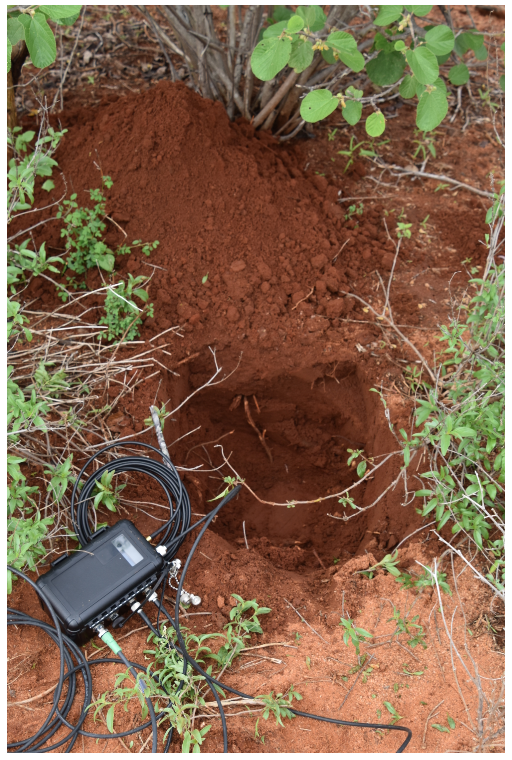
The Base Station about to be buried. The Base Station has 6 external ports: WiFi antenna, satellite antenna, a radio receive antenna, a radio transmit antenna, a power port and a sensor port. Credit: Zuzanna Reymer
3. Transmission reliability
Images and data from the field should never be lost in transmission, particularly if the system is being used for something as important as threat detection. If connections fail between devices, due to weather, animal activity or power issues, the system must be able to self-heal and anything partially transmitted should be re-sent.
The Instant Detect 2.0 LoRa radio protocol is extremely reliable as every transmission sent is acknowledged, information is not just being sent ‘in the blind’. If a transmission is interrupted or a part of it is missing a re-send request is made. The protocol will not interfere with or be interfered by other radios in the area and we have designed the system to meet all the legal requirements needed for certification.
Meanwhile the Iridium satellite constellation has 66 new low-earth orbit satellites with some in orbit being unused and kept as back-ups. These satellites provide overlapping global coverage and Iridium can even do satellite to satellite data routing.
4. System diagnostics
The field is a harsh place so we have designed and built Instant Detect 2.0 to be highly ruggedised and robust, but as with all technology it will eventually need maintenance. The system should therefore keep the conservationist constantly informed so that they know when everything is working well or when devices might need maintenance in the near future.
All devices in an Instant Detect 2.0 system send a daily report. This includes the device’s battery status, memory status, signal strength and how many images or sensor events they have recorded. Cameras can also be programmed to send an image so that a user can check the camera field of view is clear and correct.
Theft and animal interference will trigger a device’s tamper alarm and send an alert to a user if the device is moved. We did not include GPS tracking though in order to keep the price down.

An Instant Detect 2.0 camera prototype camouflaged using gorilla tape and a hula skirt type thing made by CamBush. This camera has a wide-angle lens to be used for threat detection deployments. When camouflaged the camera is hidden in a likely threat location inside a wildlife protected area where it will take an image of a passing threat and then transmits the image to a response team in a short space of time. A metal detecting sensor is used to trigger the camera rather than a passive infra-red sensor. This ensures only humans carrying metal, i.e. poachers, are detected and the response team does not get over loaded with false alerts. Credit: Sam Seccombe
5. Ease of use
The system should be easy to use, set-up and maintain by even the most untechnical conservationists so that they can focus on their conservation work and not on the technology that is supposed to be helping them.
Instant Detect 2.0 devices have been designed to be easy to set-up by a non-technical user. Lights on enclosures show key information like battery and signal strength and if the device sensor is triggering.
For the more complicated settings and to see the camera’s field of view or the contents of the SD card we have developed an intuitive Observation, Administration and Maintenance (OAM) tool. The OAM Tool is like an app served up by a device using a Wi-Fi portal that can be accessed using a web browser on a smart phone, tablet or laptop.
6. Power
To be able to work anywhere with no visible infrastructure, all parts of the system should operate from batteries. As systems will be deployed in very remote places the batteries should last for months at a time.
The Instant Detect 2.0 devices are designed to be extremely low power and sleep whenever possible so that the system can stay in the field longer between battery maintenance. The camera and endpoints come with high density internal rechargeable lithium ion battery packs (and a spare set for quick swapping in the field). An external IP67 connector is also available on every device so that they can be powered by external batteries, which could be recharged from solar panels.
The prototype devices we have tested are using more power than we would like when in sleep state. We are now working on reducing this power consumption but have also developed a number of options to change the components being used. However, we will wait for longer field trials of the system to see how much this issue will actually impact the system use.

Sam Seccombe positioning a metal triggered camera low down in a scrubby bush to the side of a vehicle track for a test deployment. The wide-angle lens allows a greater freedom for camera positioning. Because the camera is not using a passive infra-red (PIR) sensor to trigger, it can be placed at more extreme angles or distances from the track and can even have foliage partially obscuring it’s view with no risk for false triggers that can often be caused with a PIR sensor detecting foliage; this greatly improves covertness. Credit: Zuzanna Reymer
7. Camera
It seems ironic that most trail cameras being used by conservationists have been designed for the deer hunting market. We were initially reluctant to build our own trail camera as so many good off-the-shelf ones already existed with big companies behind them who can continually develop, improve and outcompete each other in the market. However, it became apparent that to meet all our users’ functional and performance requirements we would have to.
With this realisation we designed a camera specifically for conservationists using the performance of leading trail camera brands such as Reconyx and Bushnell as a baseline, but incorporating a number of additional capabilities.
The Instant Detect 2.0 camera has a 5 megapixel image sensor and can be fitted with high quality optics that can provide a range of focal lengths, giving either wide or zoomed field of views. It is triggered by a highly tuned Passive Infra-Red (PIR) sensor that detects heat and motion and minimises false alerts but can also be triggered by an external sensor for other conservation requirements. For example, the camera can be targeted to only trigger in the presence of human poachers by using a metal detecting sensor.
The camera has also been designed with the future in mind and so contains a powerful processor running a Linux operating system that has the processing overhead and capability to run automatic image recognition algorithms on captured images to determine whether to send them or not.

A camera comparison test between two Instant Detect 2.0 camera prototypes (in the middle), a Bushnell (top) and a Reconyx (bottom). By looking at the images captured it is possible to determine whether the passive infra-red sensitivity and detection speed of the prototypes matches the off-the-shelf cameras. Credit: Sam Seccombe
8. Cloud based data and alert management
A single trail camera can generate huge numbers of images that someone will then need to review, analyse, annotate and store. If these images are combined with other sensor data this process can become especially complicated.
Instant Detect 2.0 will come with a powerful cloud-based user interface, which is being developed by our partner Nominet, to make viewing, managing, analysing, and storing incoming images and data simple and intuitive on a secure but easily accessible platform. We hope it will shorten the typically long data and image processing and analysis cycle and enable more responsive conservation efforts.
From this cloud-based interface it will also be possible to change the settings of a device remotely so if a control needs tweaking or a sensitivity setting increased this doesn’t require an arduous trek into the wilderness.
With well documented APIs it should be possible to use other cloud-based tools with the interface, from image recognition processing of received images for automatic classification and tagging, to alert functions which automatically forward key information as emails, texts or text-to-voice radio messages.
Next steps
We plan to complete hardware and software optimisation of the system by the end of this year, giving us a ready-for-manufacture version of the system that meets all our design specifications. At this stage, although technically ready, we do not want to launch the system until we have completed field trials where we will deploy the system for a number of months to make sure everything performs as intended.
These trial systems will be deployed in real field sites that are representative of the diverse environments and uses for which Instant Detect 2.0 might be deployed. Each system’s performance during the trials will be closely monitored so that any issues that arise can be rectified.
If the field trials show that Instant Detect 2.0 is ready, it is planned that by early 2020 we can scale up manufacture and make Instant Detect 2.0 available to the wider conservation community.
About the Author
Sam Seccombe is Technical Project Manager in the Conservation Technology Unit at the Zoological Society of London. He is currently working on Instant Detect 2.0 and spending time in Tsavo West in Kenya testing and trailling new equipment. Sam studied Zoology (2.1 Hons) at Bristol University, specialising in animal behaviour and previously spent 4.5 years in a front-line reconnaissance Regiment in the British Army, leaving at the rank of Captain.
16 November 2023 1:11am
I am doing a research project on rhino poaching at Kruger National Park. I was impressed with the idea of Instant Detect 2.0. I do not know the cost involved with installing that and tried to reach out but in vein. If the cost cannot be defined, I cannot move forward with the idea. Doyouhave any information regarding the same?
![]()
What do you suggest is a good idea? I cannot be suggesting something they are already doing.
Kaarthika Chandran