
WILDLABS Team
Date & Time
Thursday, June 6th
3:00-4:30pm BST / 10:00-11:30am EDT (check your timezone here)
Background & Need
The illegal wildlife trade threatens the very existence of species such as tigers, rhino, and pangolins. Technology offers hope in the battle against this destructive illegal market.
The WILDLABS Tech Hub is helping advance innovative solutions taking on the illegal wildlife trade. It brings together the Foreign & Commonwealth Office, Digital Catapult, Satellite Applications Catapult, Amazon Web Services, Microsoft, and six international conservation partners supporting WILDLABS.NET. From this network, the solutions have access to a wide range of resources, including technical consultation with cloud experts, business model design sprints, and connection to in-field labs for testing and feedback.
This virtual meetup is an opportunity to hear first-hand how these solutions are scaling their technology, and achieving sustainability, in the drive to make a lasting difference. From cutting-edge forensic technology and open hardware to cloud-enabled data aggregation and satellite networks, the participants in the WILDLABS Tech Hub represent a diverse and inspiring cross-section of approaches:
- An IoT and web platform that can transmit images from remote cameras or live video streams to AI modules which search for relevant threats (people, vehicles, animals), and can alert users in real time.
- A constellation of lightweight and low-cost satellites to track tiny, low-cost sensors deployed on animals, vehicles, etc. Real-time, accurate satellite-based location tracking anywhere, at low cost.
- Open-source acoustic hardware and software for environmental & wildlife monitoring, with existing applications including automating the search for an elusive insect species, monitoring poaching by gunshot, and listening for ultrasonic bat calls.
- A fingerprint database available internationally for the storage and search of fingerprints from people involved in or believed to be involved in wildlife crime and fingermarks from wildlife crime scenes.
As well as their journey and progress to date, you will learn about advances in the conservation technology sector, what the future holds for these solutions, and how you can get involved.
Agenda
- Welcome and introductions (5 min)
- Tracy Alexander, Director of Forensics at City of London Police (10 min)
- Aurélie Shapiro, Senior Remote Sensing Specialist at WWF, PandaSat project lead (10 min)
- Eric Schmidt, Executive Director at Wildlife Protection Solutions (10 min)
- Peter Prince, Algorithm & Software Design at Open Acoustic Devices (10 min)
- Q&A discussion with speakers (35 min)
- Takeaways and wrap up (10 min)
Watch the Virtual Meetup
(Click through here to watch the full meetup)
Virtual Meetup Notes
During this Virtual Meetup Special featuring the winners of the WILDLABS TECH HUB, we were joined by 100+ attendees from at least 28 countries around the world! Thanks to everyone who participated in the live chat and community discussion. For those of you who were unable to join live, we've recorded the session so that you may view it at your convenience. We've also shared presentation notes and further reading suggestions below.
Speaker: Eric Schmidt
Background
- Wildlife Protection Solutions is a nonprofit based in the US with various projects throughout Sub-Saharan Africa and Southeast Asia
- 16 individuals on staff with a wide range of expertise
- Past several years have focused on deploying camera technologies in the field to figure out how to best get connected camera systems to work in challenging environments
System for active engagement with local partners
- Understand specific tech needs and risks
- Determine what power solution might be most appropriate for the region
- Establish long-range connectivity solutions
- Identify useful field sensors
- Implement proper processes and practices surrounding tech give local partners ownership and make it sustainable
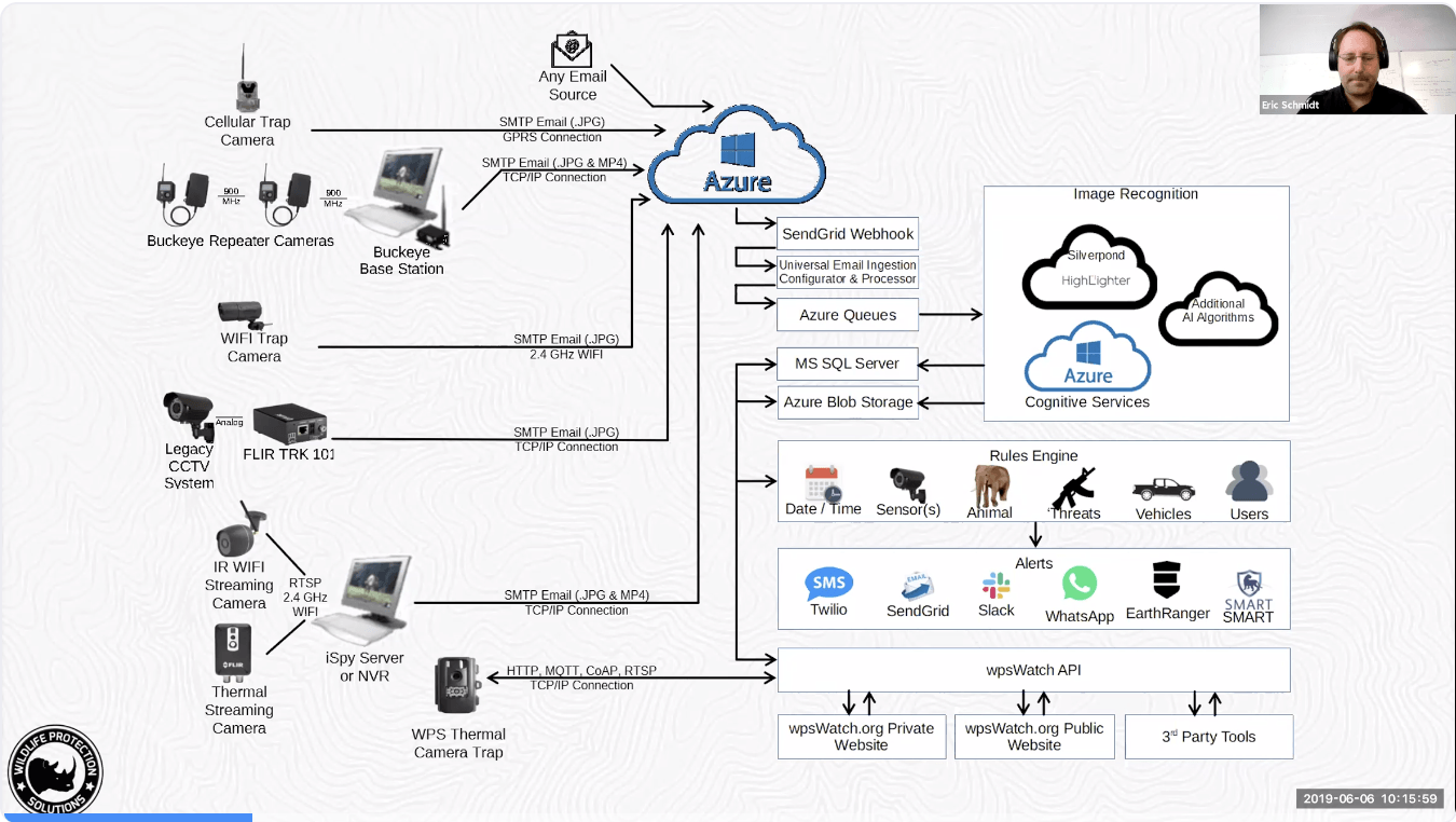
Web platform to engage with image sensors
- Bring info in through cellular networks, private repeater networks, or long range wifi systems
- Pull info into series of threat assessment or other AI routines (e.g. identifying vehicles/intruders or specific species/animals)
- Get information to stakeholders and first responders
- On the ground in patrols or anti-poaching units
- People in local joint operation centers or dispatch areas
- Global stakeholders
- Citizen security: can also share information with trusted/vetted volunteers to take advantage of time shifting to get good coverage even for places that can’t afford 24-hour monitoring on the ground
System impact (examples)
- Cameras picked up on repeated suspicious daily intrusions by same individuals in a remote protected area too far for an immediate response – WPS notified wardens of the intrusion schedule and locations, and on the 4th day a response team was waiting, and appropriate arrests were made
- Another park with important biological assets was facing many incursions from a surrounding community. WPS assessed topology and potential intrusion points and set up monitoring of likely paths of poachers. Within 2 weeks cameras caught poachers at 2:00am local time, someone monitoring in the US caught it, and rhino protection units were activated in time to pursue intruders
How it works
- The platform is designed to work with a broad range of types of imagery and video streaming solutions (including any email source that can transmit imagery)
- All of the incoming info gets fed into an Azure cloud platform
- Through a variety of techniques, we run it through AI analytics and see whether there are any alerts we need to make partners aware of
- Our rules engine also allows you to set up, on a per-sensor basis, schedules, alerts for animals, threats, vehicles, etc. and distribute it to users through convenient platforms (WhatsApp, SMS, Slack, SMART, and more)
- We also have an API in release to allow people to have public/private access to wpsWatch.org web platform to see and monitor data
- Finally, we're also working on directly integrated camera traps with a variety of partners including WWF
Final notes
- This platform has been a success so far, with 24 implementations and more than 200 incursions detected
- As a nonprofit, we’re offering this service free of charge to anyone who could benefit from our work!
Speaker: Aurelie Shapiro
Background
- PandaSat vision is to transform wildlife conservation with innovative tracking technology
- Accurate geolocation is essential for conservation action since wildlife move beyond borders and migrations are changing due to ecological and anthropogenic pressures
- 2008 example from Where the Animals Go – 2 zebras were tracked with collars over a year in Botswana and the data demonstrated how fences were impacting their movement
- Years later in 2014 WWF tracked zebras nearby and captured the longest recorded terrestrial migration in the world
Existing tracking solutions are…
- Too heavy for many animals
- Too expensive for large-scale tracking
- Too error-prone for effective action
Our solution: PandaSat
- Worldwide coverage with <100m accuracy
- Lightweight satellites (1U CubeSat) and tags (<5g tags)
- Long battery life (>1 year)
- Low price (due to low energy usage and small size)
- Global reach with WWF brand and expertise
Our target
- Today we estimate fewer than 50K animals are tagged globally
- With PandaSat, our 2022 target is to double that by:
- Going beyond wildlife into vehicles, ranger equipment, etc.
- Larger scale tagging – better access in marine environments
- More replication – tagging more individuals rather than just 1 or two in a group
- Smaller wildlife
- Tracking shipments covertly to understand the movement of illicit products
How it works
- Old school / traditional
- Large animals with large tracking collars
- Data transmitted to a large, expensive satellite that takes years to develop and launch which makes it challenging to keep up with quickly advancing tech on the ground
- PandaSat
- Tags the size of a penny at a low cost ($20-50 USD)
- Data transmitted to multiple smaller (10x10x10 cm), lightweight CubeSats from Stanford University at low material cost ($20-50K) to increase coverage
- Reduce invasiveness and negative impact of tags – could be ear tags, etc. instead of bulky collars
-
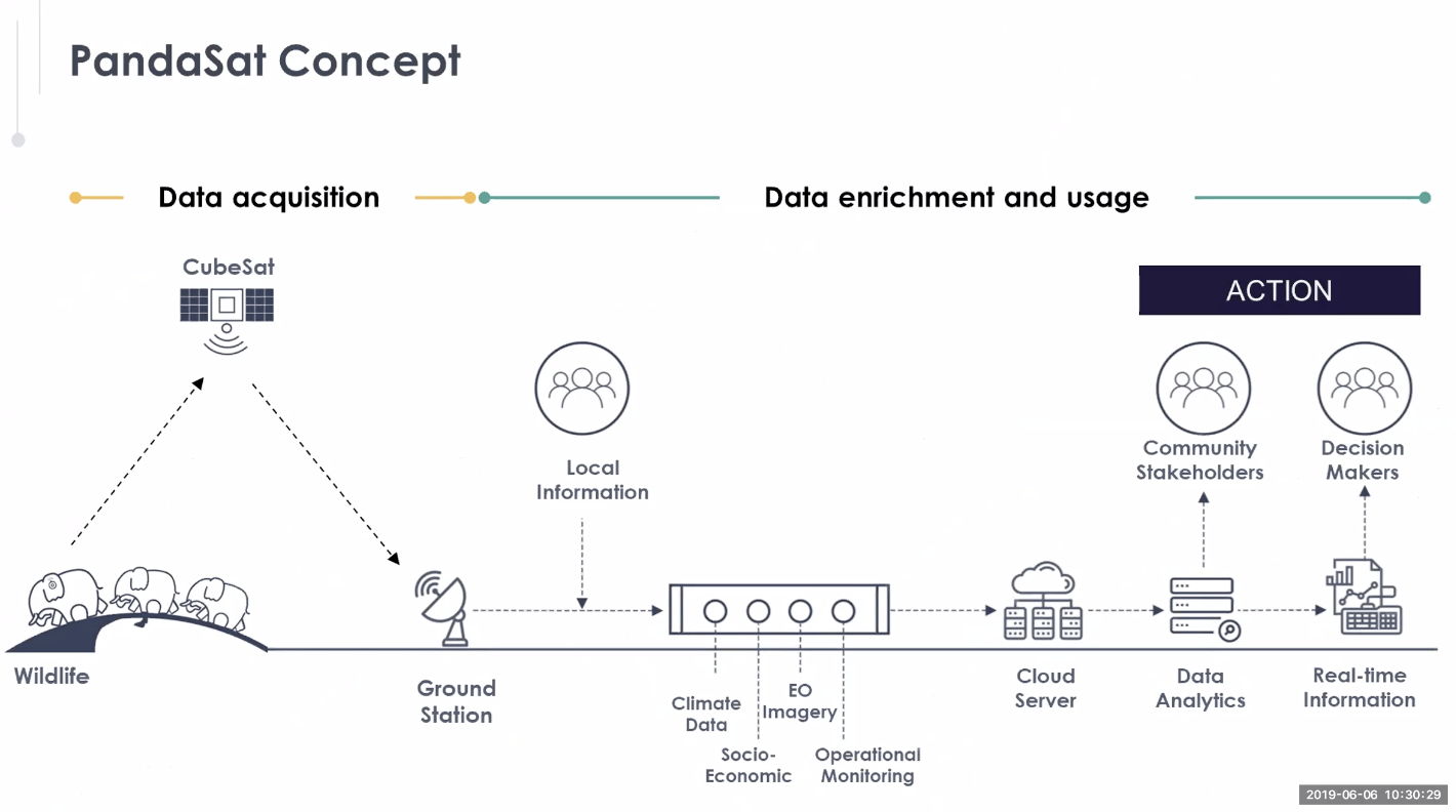
- Collect data from wildlife via CubeSats
- Transmit data down to a ground station
- Data enrichment and usage
- Combine tracking data with info from location experts, earth observation imagery, climate data, socioeconomic information, etc.
- Process information in a cloud server with data analytics
- Distribute data to community stakeholders and decision makers
Use cases
- Areas in wildlife conservation: human-wildlife conflict, anti-poaching, conservation planning, and scientific research
- WWF example: Grey parrots in Cameroon
- Endangered species being captured and sold illegally into trade at markets
- WWF works to release them into the wild but has no way of knowing what happens or where they go after release to understand the bigger picture and prevent capture in the first place
- Also potential for nature conservation, humanitarian, and commercial applications
Alternative solutions
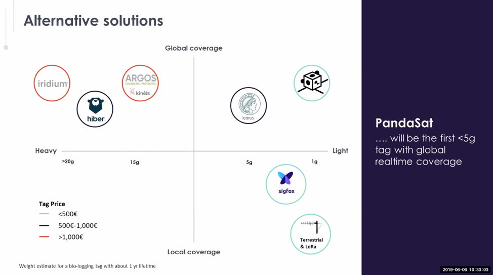
- PandaSat will be the first <5g tag with real-time global coverage
Team
- Zac Manchester – Assistant Professor of Aeronautics and Astronautics at Stanford University
- Rob Maccurdy – Assistant Professor of Robotics and System Design at the University of Colorado Boulder
- Aurelie Shapiro – Senior Remote Sensing Specialist at WWF Germany
- Sam Harper – Head of Global Business Systems at WWF International
- Ravi Kapur – Director and Founder at Imperative Space
Roadmap
- Phase 1: R&D and Proof of Concept (2019–2020)
- Build tag prototypes and field test
- Evaluate use cases and market
- Launch and test CubeSat prototypes
- Phase 2: Scale & Public Launch (2021–2022)
- MVP release
- First tag production
- Further satellite launches
- Phase 3: Expansion & Commercialization (2022 – beyond)
- Market expansion
- Further tag and product development
- Infrastructure maintenance
Our asks
- Tag development partners – adapt tags to unique environments, species, and uses cases
- Satellite launches – take a PandaSat with you to space
- Data support – ground station and value-added analysis, A.I.
- Customers – let us know how PandaSat could help you!
Speaker: Peter Prince
Background
- Open Acoustic Devices – interdisciplinary research group from the University of Southampton and Oxford University
- The rest of the team: Andy Hill, Alex Rogers, Jake Snaddon, and Patrick Doncaster
- Developed an open source tool for monitoring the environment with sound
AudioMoth beginnings
- This research was born out of a concern for jaguar populations having to compete with local bushmeat poachers for prey in Central America
- Jaguars are elusive and difficult to monitor
- Poachers were killing with guns at close range
- Idea: Can we use sound to monitor poaching in jaguar habitat?
- Aim: Create a network of acoustic devices to inform us of where and when poaching happened most frequently
- Research questions:
- What hardware can be used to monitor sound in these remote areas?
- Can we detect gunshot events using this hardware in real time?
Hardware
- The hardware challenge: Available tech for acoustic monitoring is too expensive to use at a large scale, power hungry, large, and difficult to customize (closed-source)
- The hardware solution: An open-source acoustic device
- Used microphone tech from smartphones
- Reduced cost by:
- Limited computing power
- Removing expensive enclosures
- Removed cable assemblies
- Used small components to reduce the size (only about as large as a credit card!)
Gunshot detection
- Used real-time detection to filter out what’s recorded to memory, we were able to increase battery life and reduce onboard memory requirements
- Detection algorithms vary greatly in complexity from simple interactions between frequency bands to machine learning
- Used machine learning to determine characteristics of gunshot sounds and record only when similar patterns appear
- A year ago, first gunshot detection devices were deployed in Belize – a couple of weeks ago they retrieved data from them
- Battery life was maintained for a year while collecting useful gunshot data!
Accessibility
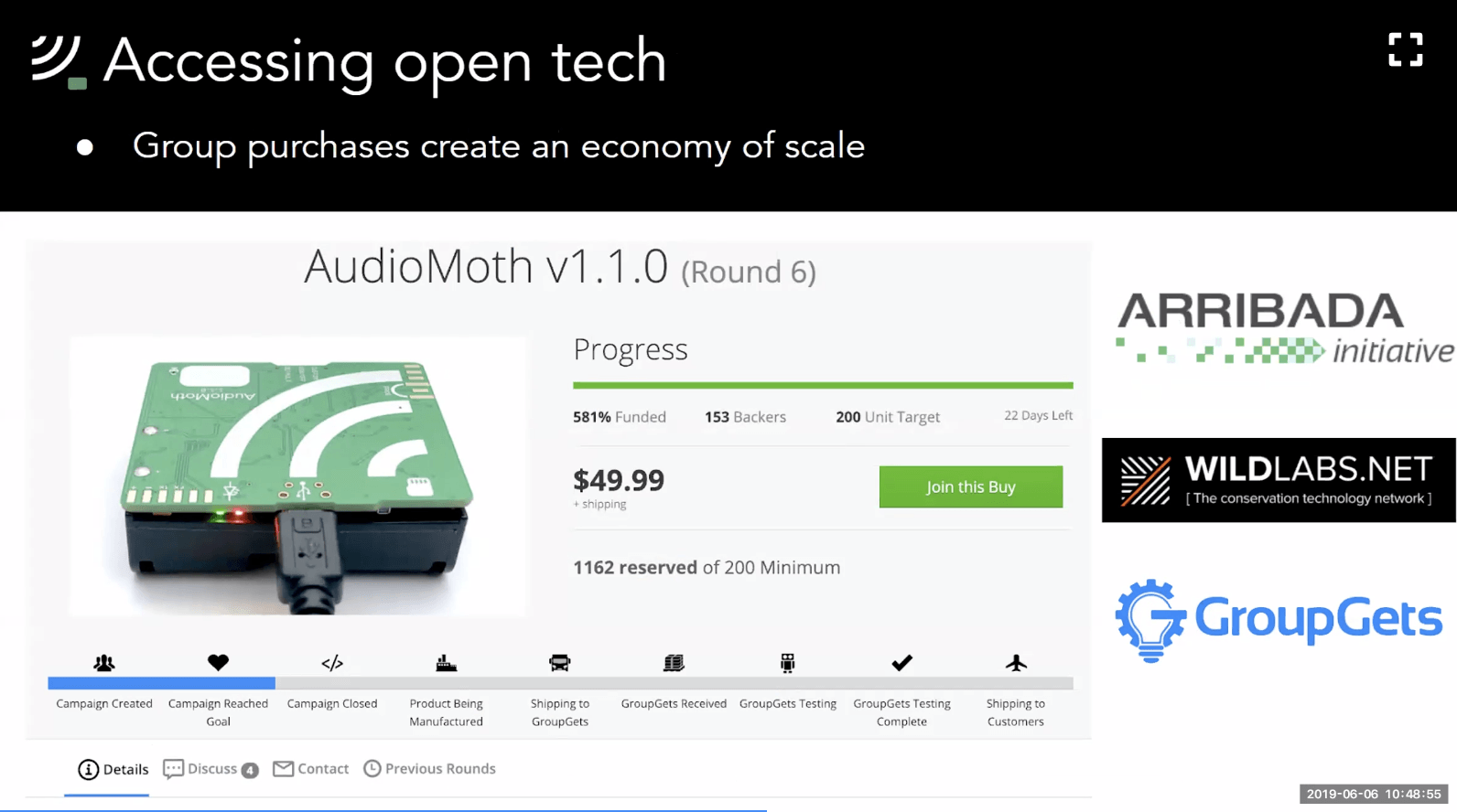
- Open source: AudioMoth hardware and software made open source online in 2017 so that others could share and adjust for their own projects
- Group purchases:
- The simple design meant they could be manufactured as a single working unit from one manufacturer, which helped keep the cost down
- By ordering in bigger batches through a group buy prices per unit were brought down significantly
- With the Arribada Initiative and the WILDLABS community, the group purchase brought the cost down £32 per unit
- Have now run 7 rounds of group purchases and distributed 6000 devices to conservationists around the world
- Join the next group purchase here
The AudioMoth Community
- Over 1,000 users all over the world using AudioMoths in different ways
- Examples
- Greenland: monitoring migrating birds
- Kenya: monitoring large mammal wildlife corridors
- Malaysia: monitoring amphibians in montane forests
- Cuba: searching for elusive bats
- Florida: listening for manatee and dolphin calls (underwater!)
- Future challenges
- Continued community support after funding ends
- Sustainable business model
- Improving the user/developer experience
- AudioMoth data storage and analysis
- Real-time alerts using acoustic triggers
Speaker: Tracy Alexander
Background
- Directs forensic services for the City of London Police
- Work incorporates chemical enhancement of fingerprints and fingerprint identification (today’s topic) but also training, contracts, DNA analytical services, toxicology, and more
- These techniques prepare us to deal with a variety of crime types, including high tech digital and cybercrime, coronial investigations, scenes of crime, etc.
Identifying parties involved in wildlife crime
- Importance: poaching is a massive problem
- E.g. 100,000 elephants killed for ivory between 2010-2012, gradual decline since then but no decline in demand and still an estimated 55 killed illegally every day
- Other species like pangolins and rhino face even more severe threats due to trade
- Solution:
- Using fingerprint identification to identify who is participating, how, and ultimately who are the beneficiaries of this crime and how are they driving it forward
- Sir Edward Henry developed a method of using fingerprints to identify people in 1901
- Early methods used ink and paper – while there is lots of cool potential for development, this doesn’t necessarily have to start as a high-tech solution!
Research
- Identifying fingerprints on ivory at Kings College London
- Research found that SupraNano black magnetic powder is the best method of developing fingerprints on a surface like ivory
- Interacts with sweat is excreted from tiny pores running across fingerprint ridges
- Cheap and easily usable out in the field
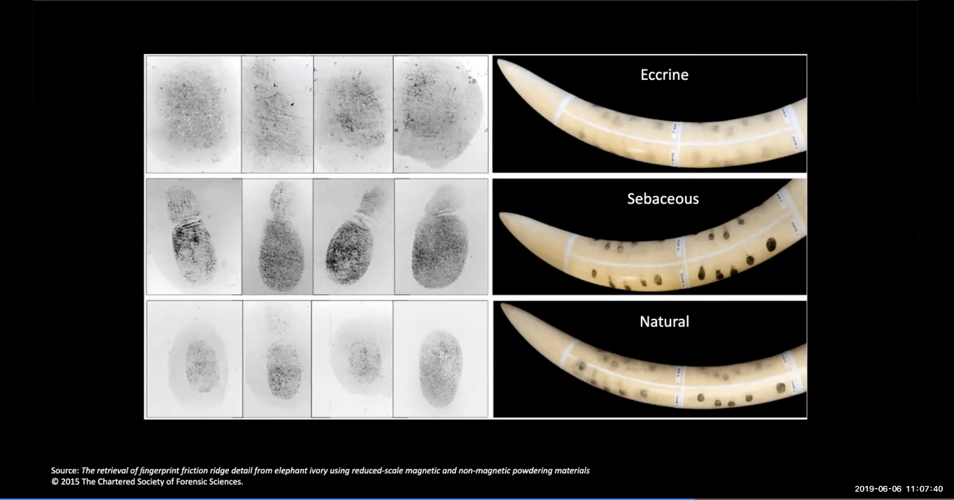
- Research answered important questions like:
- What types of sweat will the SupraNano powder interact with?
- How long after contact can marks be developed? (> 1 month, potentially longer depending on conditions)
- Will it work on other wildlife products?
- Yes, it also works on rhino horn and pangolin scales!
Implementation
- 14 prosecutions so far from using this tech at Heathrow airport, but want to be able to give this capacity to countries of origin
- IFAW has enabled distribution of these inexpensive fingerprinting kits to wildlife crime units
- Issue: Many origin countries don’t have access to fingerprint databases or fingerprint comparison technology
- Solution: a free operational response database
- Set up a small section of the UK’s national fingerprint collection searching mechanism
- Huge capacity – even with another million prints added, we’d be able to search the whole database in less than 30 seconds
- Biggest country database per capita in the world with sophisticated algorithms and more than 7 million sets of prints
- Data will remain separated by country
- Interpol (who have authority to transfer biometric data across borders) will anonymize data before it’s sent to us, and then send back results to the origin country
- Set up a small section of the UK’s national fingerprint collection searching mechanism
- Whether used for making arrests or just getting a wider intelligence picture, fingerprint information is vital – it accounts for more 40% of every forensic sanctioned detection that we make
- Instant matching technology is now available via an app that can be used on a smartphone or iPad
- African Parks is enabling effective intelligence across their park network by giving parks access to an intelligence database – data sharing to tackle crime
Training (flexible 3-day schedule)
- Crime scene management: crime scene processes, the role of the Crime Scene Examiner, and Crime Scene Manager and best evidence
- Scene of the crime: appropriate collection of fingerprints from a range of surfaces, appropriate to environmental conditions
- Intelligence and evidence: recovery of DNA from crime scenes and likelihood of success; potential evidential value of DNA matches; sources of DNA and presumptive testing; toxicology, weapons examination, firearms, and ballistics
- Current training programs set up for Zimbabwe, Zambia, and Tanzania
Final messages on Poreprint
- UK-based database is not a permanent solution – it’s a way to get this technology off the ground in countries without another option right now and to demonstrate the utility of these simple, affordable methods
- How to help/ get involved:
- Connect us with wildlife crime units or investigators that would appreciate access to this technology, and we’ll make it happen!
- Share information or connect us with potential trainees or sponsors to continue to build this program
Further Reading
Links referenced in the live chat:
- A recent study on how machine learning can help fight illegal wildlife trade on social media
- The recording and notes from our virtual meetup on Next-Generation Wildlife Tracking, which gives some more useful context for understanding the ecosystem PandaSat is entering
- The WILDLABS Wildlife Crime community group
- Point of contact (Liz Barrow) for an upcoming funding opportunity from the European Space Agency for feasibility studies focused on tackling environmental crimes
Next Steps
- Jump over to this thread to continue the conversation.
- Register here to join our next meetup on Creative Approaches to Data-Driven Storytelling!
Add the first post in this thread.