
WILDLABS Team
Overview
The WILDLABS Virtual Meetup Series is a program of webinars for community members and wider partners to discuss emerging topics in conservation technology and leverage existing community groups for virtual exchange. The aim of the series is to bring leading engineers in the tech sector together with conservation practitioners to share information, identify obstacles, and discuss how to best move forward.
The series begins in late 2018 and will be hosted on WILDLABS via Zoom. The three topics to be covered include this Networked Sensors for Security and Human-Wildlife Conflict (HWC) Prevention, Next-Generation Wildlife Tracking, and Big Data in Conservation. The first two topics center around data collection, on wildlife populations through tracking and on protected areas and community boundaries through networked sensors, while the third topic tackles how to most effectively utilize that data.
There is a lively discussion about possible topics members would like to have space to discuss, so if you have ideas for future meetups please join the thread and share your thoughts.
Meetup 1: Networked Sensors for Security and HWC Prevention
Background & Need
Much of today’s human-wildlife conflict could be mitigated by the early detection of unwelcome wildlife in human areas. Likewise, security threats to species at risk of poaching could be reduced by the early detection of unwelcome humans in wildlife areas. Sensors equip a range of tools to enhance monitoring capacity for conservation, and when networked, hold the potential to revolutionize such early warning systems. There are currently numerous endeavors underway to implement networked sensors in both protected area security and HWC prevention, from efforts to secure parks and protected areas from poaching such as the Wildlife Crime Technology Project to those implementing LoRa-based integrated fencing networks such as the winners of the 2017 HWC Tech Challenge. Groups working in this arena from the WILDLABS community and beyond will benefit from a centralized discussion to help identify points of overlap, potential collaboration opportunities, and remaining gaps to be addressed.
Outcomes
The aims of this discussion are as follows: to introduce networked sensors in the context of conservation; to describe how they are being used for conservation, including what needs they are addressing in conservation practice and how different approaches fit together; to identify the obstacles in advancing the capacity of these technologies from both field and tech perspectives; and to discuss the future of networked sensors, including the sustainability of their applications and how best to collaborate moving forward.
Agenda
- Welcome and introductions (5 min)
- Eric Becker Conservation Technology Engineer, World Wildlife Fund (10 min)
- Laurens de Groot, Co-Founder, SmartParks (10 min)
- Dr. Jan-Kees Schakel Founder and CEO, Sensing Clues (10 min)
- Q&A discussion (15 min)
- Take-aways and wrap up (5 min)
Virtual Meetup Notes
For our first-ever WILDLABS Virtual meetup, we were joined by 70 attendees! A big thank you to everyone who participated in the live chat throughout the session and the end discussion with such enthusiasm. We hope you enjoyed it as much as we did. For those of you who weren't able to join in person, we've recorded the session so you will be able to view it at your convenience, and we've shared key takeaways in the notes below.
Speaker: Eric Becker
Background
Working on WWF’s Wildlife Crime Technology Project
- Substantial time spent in the field, integrating tech solutions in protected areas, increasing capacity of rangers on the ground
- Zero Poaching Model
Challenges in the Field
Patrol side:
- Inability to see at night
- Patrolling vast areas with limited manpower
- Limited reliable power source
- Limited respond to events in real-time
- Limited communication capacity
WWF/ Tech side:
- Get and maintain buy-in of rangers and park management
- Wildlife and weather proofing
- Limited supplies (bring spares!)
- Limited on-site tech expertise (training people who may have never used a computer in their lives)
Wildlife Crime Technology Project
- Started in 2013 with a Global Impact Award
- Initial focus was UAVs to stop poaching – quickly identified issues with using drones as “the answer” including cost barriers, flight time, size of areas needing to be covered
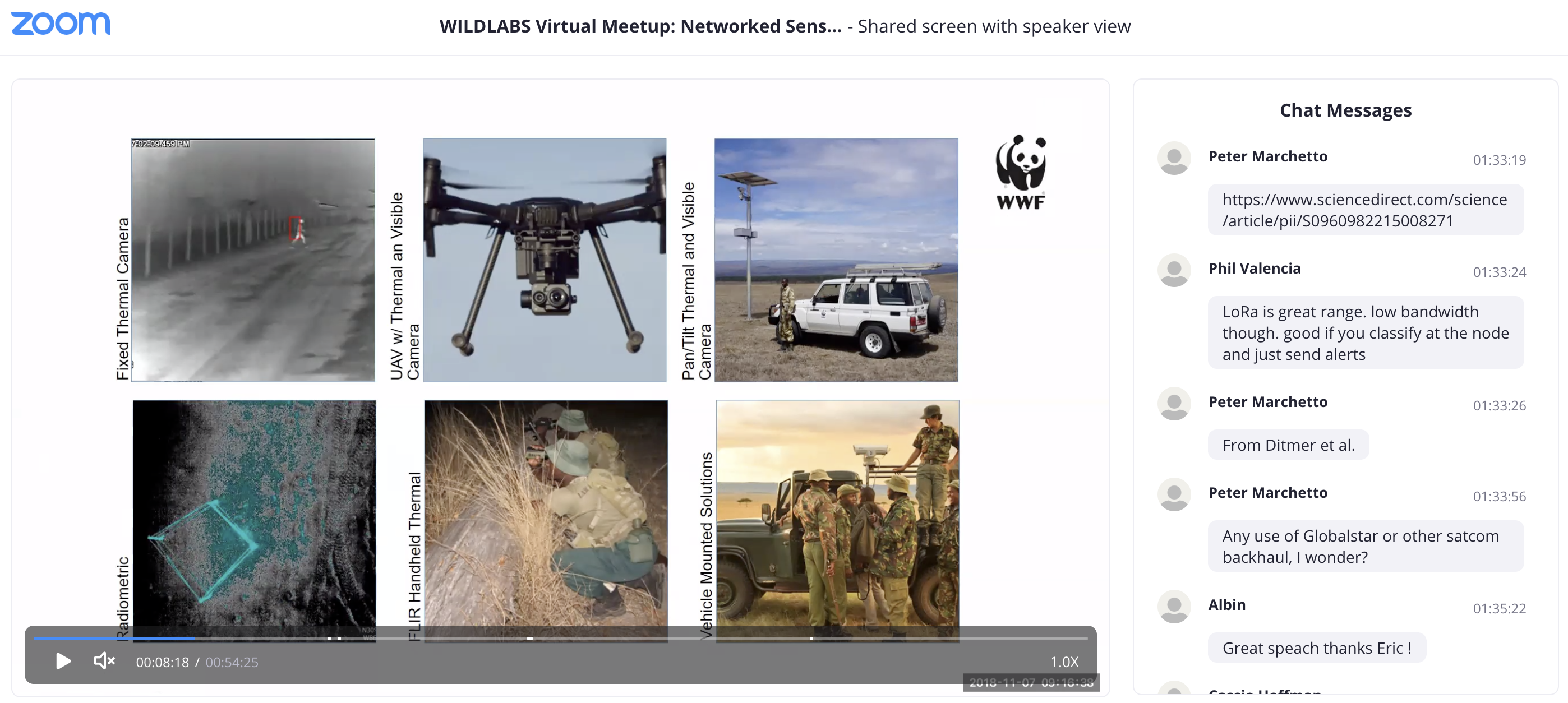
- A new solution – identified need for long-range night vision, used thermal cameras to achieve this. Included:
- Networked static fixed cameras along boundaries
- Networked scanning 360 fixed cameras with onboard computer (can look for humans etc.)
- Multi-rotor UAVs to minimize human-wildlife conflict (elephants don’t like the sound) and as rapid response tool
- Want to be able to respond before the target leaves the sensor’s field of view – UAVs can get eyes on the intruder quickly
- Topical Discussion: Effect of drone flight on wild animals
- Radiometric thermal cameras – get accurate temperature readings from images – use for habitat monitoring, wildlife monitoring
- Hand-held thermal cameras + vehicle mounted thermal cameras
- Analytics
- System’s human classifier will send out alert in real time when a potential intruder is identified
- Rely heavily on analytics to identify what’s important because park rangers can’t monitor every camera all the time
Connected Conservation effort with Cisco and FLIR in Zambia
- Providing network coverage to enable future tech deployments
- Currently installing infrastructure, hoping to have it live in next few months to then integrate other tech like narrow-band LoRA
- Topical Live Question: Infrared/Thermal Cameras to Install in Conservation Perimeter Fence?
Using radar to fight snare crisis
- Problem: snares used as indiscriminate killers of wildlife, and they’re difficult to see with human eye
- Solution: developing a synthetic-aperture radar to put on a drone and do change detection to be able to find metal snares hidden within habitat – will be tested at the end of the month, updates to come.
- Topical Discussion: Snare Detection Technologies
Speaker: Laurens de Groot
Background
- Previously worked as a crime investigator, got involved in conservation in part due to frustrations with lax punishments for wildlife crimes – went to Antarctica to go after illegal Japanese whaling vessels
- Started looking into how tech could give them advantages in catching criminals – got some backlash from their targets (criminal harpoon ran through their vessel and sank it in the Antarctic)
Drones in Namibia
- Had previously attempt to film illegal clubbing of seals with drones – not a lot of success due to strong winds and issues with early designs
- Went to greater Kruger with their own design (EcoRanger) and caught two poachers on video. This Started them on a path to more drone projects in the U.S. and Borneo
- Despite clear advantages, they ran into many of the same limitations that Eric/WWF had, and determined that they weren’t a sustainable conservation solution
LoRa sensors in Tanzania
- Connected with SmartParks Co-Founder Tim van Dam, who was attempting to implant LoRa sensors in horns of Eastern black rhino (hard to collar, difficulties using radio)
- Proof of concept in Mkomazi National Park in Tanzania using triangulation to locate the Rhino
- The system has been running for over a year now with location updates every 7 minutes
- Hoping to expand to more animals and locations
- Since winning the 2017 Human-Wildlife Tech Challenge hosted by WWF-Netherlands and WILDLABS they have been able to expand to test their sensors in human-elephant conflict mitigation in India. Read more: Smart Electric Fence Solution
- They are working with other tech challenge winner Arribada Initiative (headed by WILDLABS member Alasdair Davies) to incorporate their new thermal sensors to detect elephants more quickly. Read more: Thermal Sensors Project

SmartParks workflow in 5 steps
- Feasibility study based on geography
- Building the network
- Implementing sensors
- Gather data in control rooms – to be run on the premise (rather than cloud-based application which is hard with limited connection)
- Park management takes over park monitoring with increased awareness
Road ahead
- Current projects in Tanzania, Malawi, Rwanda, India, and now the Netherlands
- Future marine work in Mozambique monitoring baby turtles and dugongs
- Expanding work with African Parks, aiming to cover over 10 national parks in coming years covering over 6 million hectares in seven countries
- African Parks plays a big role in getting park infrastructure (gates, security, rangers, etc.) to the place where implementing SmartParks technology will be of use
- Moving from just a charitable not-for-profit to a social enterprise to build a sustainable business and open doors for larger entities to cover operational costs when possible
Speaker: Jan-Kees Schackel
Background
- Natural resource management and policing
- Founded Sensing Clues in 2015 with the mission to make available best-of-breed technologies to conserve ecosystems and protect wildlife. Works as connection between tech companies and conservation-related law enforcement to help create effective sensing networks
Definitions
- Distinction between early warning and fast response phases and technologies required for each
- Distinction between people and their behavior – e.g. being a thief isn’t a crime, but stealing is – importance of catching poachers in action
- Sensing is sentience automation, from sensor to sensemaking (each sensor describes only part of the picture) and the point is to inform enforcement action
SCCSS Wildlife Intelligence Platform
- To be released in next month or two
- To improve situational awareness in parks they start small and build up, as many do not have funding to do large overhauls right away
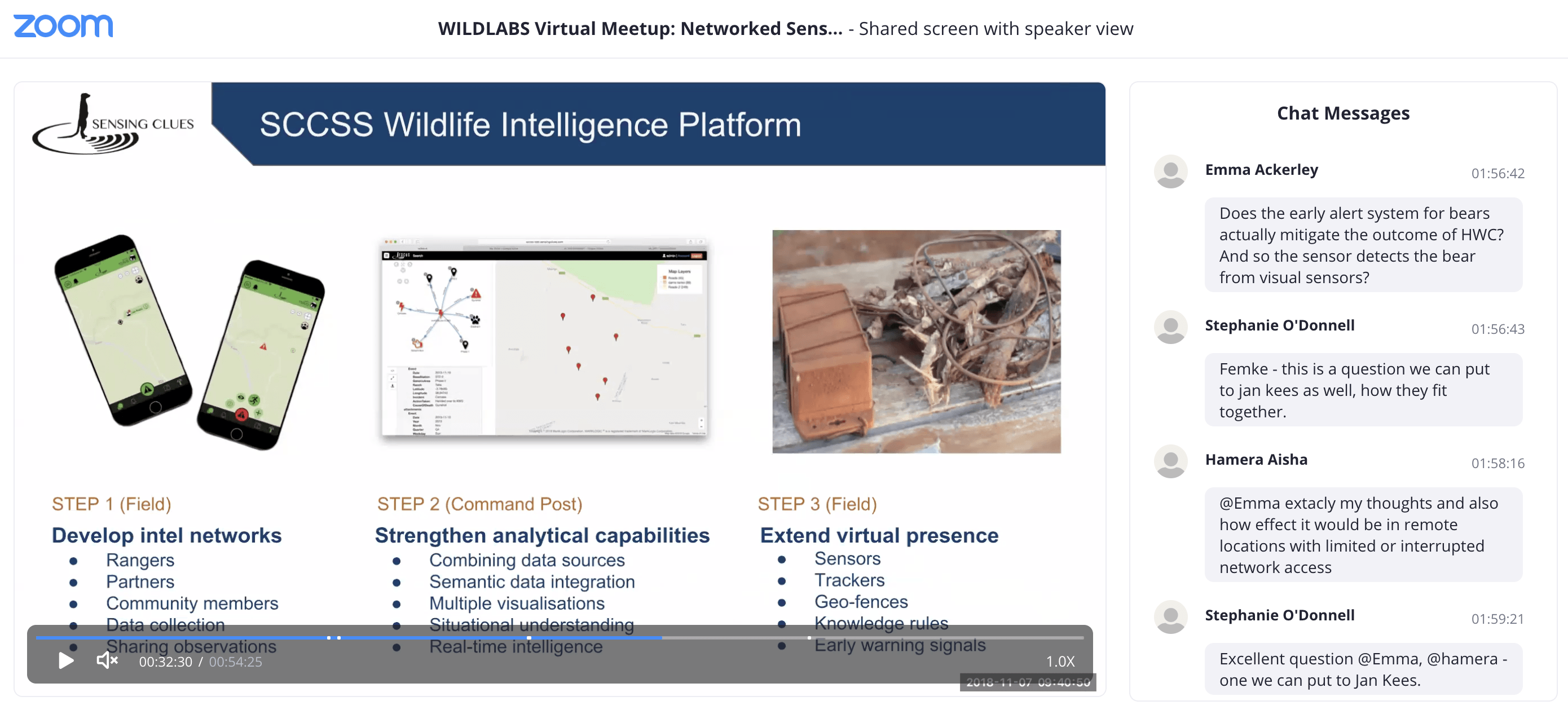
- Step 1: Develop intel networks (field)
- Share observations and sensor alerts via mobile App that functions offline (being used in South Africa and the Netherlands)
- Step 2: Strengthen analytical capabilities (command post)
- Create geofences for location-based alerts throughout the area (can be used for human-wildlife conflict mitigation to alert rangers and community)
- Use semantics to unlock data silos, get an integrated situational overview, and explore patterns (e.g. poaching coincides with charcoaling)
- Step 3: Extend virtual presence (field)
- Use sensors to detect human presence
- Sensing Clues has developed 3 new sensors – one to pick up radio signals from smartphones, one for sound detection and classification (SERVAL), and one for light detection, which all help to identify human activity in an area
- Topical Discussion: Acoustics for Human-Wildlife Conflict Prevention, Anti-poaching, and more
Questions
Q: Peter Marchetto: Eric, are you using Globalstar or any other satcom backhaul?
A: Eric Becker: Depending on how remote the site is we’ll mostly use Iridium because of the two-way comms. We use Globalstar on the tracking devices, but we haven’t required any kind of high-bandwidth backhaul yet, so we’ve been using Iridium modems as our kind of gateway.
Q: Felipe Spina Avino (and others in chat): How can we take advantage of these technologies in remote sites (e.g. Brazil) with limited resources and network access?
A: Laurens de Groot: ballpark figure on initial costs of a SmartPark is between 150,000 and 300,000 EUR, depending on lay of the land (more hills means more gateways and higher cost), as well as where and how many sensors you want.
A: Jan-Kees Schakel: for Sensing Clues solutions we start at between 5,000 and 10,000 USD and then build up capacity slowly. If you really need infrastructure and want to expand capacity substantially the costs will go up closer to 100,000 USD, but we start small where parks with fewer resources can gain capacity for a low cost.
A: Eric Becker: Not going to speak to cost, but in terms of low man power in that type of environment in Brazil it’s important to look at the poachers’ behavior – what are you looking for? Do they carry cellphones? Are they loggers? Do they use chainsaws or firearms? Once you understand the behavior of who you’re trying to detect you can look into more focused technologies to deploy to stop them.
Q: Femke Hilderink: Laurens, can you say a bit more about the SmartParks fence sensor? How it works, what it looks like etc.?
A: Laurens de Groot: In India the big problem was power leaks – elephants come and damage fences and there’s a lot of time being spent on maintenance. We wanted a solution we could connect to the thermopile sensor Alasdair (Arribada Initiative) is making. So, we designed a sensor connected to the energizer, that we connect to the fence, and it measures the battery voltage in the fence. The data coming back to us is valid but we’re getting very high values, so we’re trying to figure out if that’s because of the sensor or the installment of the fences. It looks like it’s due to the fences, which means we have to improve the sensor to make it adjust to the varying voltages.
Q: Stephanie O’Donnell (pulling from chat): How does sensing clues fit within the ecosystem that includes SMART and Vulcan’s EarthRanger (previously DAS) and others working in this space? How is it different and does it integrate with cheap or already free solutions?
A: Jan-Kees Schakel: Yes. We made it a point from the start to build our system based on open standards. So, any system that adheres to open standards can be connected to us and we can connect to them.
A: Laurens de Groot: the application we built is integrated with Vulcan’s EarthRanger. We can integrate it with pretty much everything, but when it gets really technical, I have to bring in the programmer to talk about the details.
A: Eric Becker: We’ve been partnering with Cisco and FLIR on a lot of the tech efforts with the hope of opening up the project site as a place where we can bring in engineers to test new technologies. But we’d love to work with SmartParks and Sensing Clues and see how we can integrate what you all are doing with our bigger tech project as well.
Next Steps
Feedback
If you attended, please take this quick survey to give us feedback so that we can improve future events.
Join our next Virtual Meetup
Topic: Next-Generation Wildlife Tracking
Date & Time:
Tuesday, November 20th
Main Talks: 2:00-3:00pm GMT / 9:00-10:00am EST
Additional half hour for discussion: 3:00-3:30pm / 10:00-10:30 EST
Speakers:
Christian Rutz, President of the International Bio-Logging Society (10 min)
Virginie Perilhon, Environmental Helper & Wildlife Defender at Xerius Tracking (10 min)
Jake Levenson, Co-Founder & Executive Director of Oceans Forward, Marine Biologist with US DOI (10 min)
Registration:
To join, register here: https://wwfus.zoom.us/meeting/register/0a1446eebb1541757c24e00bf0acd2b8
Related content
Event
The second event in Season One of the WILDLABS Virtual Meetup Series was on Next-Generation Wildlife Tracking. The recording is now available to watch, along with notes that highlight the key takeaways from the talks...
12 November 2018
Event
WILDLABS Virtual Meetup: Big Data in Conservation

WILDLABS Team
The third and final event in Season One of the WILDLABS Virtual Meetup Series was on Big Data in Conservation. The recording is now available to watch, along with notes that highlight the key takeaways from the talks...
27 November 2018
Add the first post in this thread.