GIS, or Geographic Information Systems, play a crucial role in nature conservation. Every day, mapping and spatial analysis are aiding conservation decisions, protected areas designation, habitat management on reserves and monitoring of wildlife populations, to name but a few examples. Want to learn more about how remote sensing is used in conservation? Check out the first two episodes of this season of Tech Tutors, where our Tutors answer the questions How do I use open source remote sensing data to monitor fishing? and How do I access and visualise open source remote sensing data in Google Earth Engine?
You can also check out our Virtual Meetup Archive for a range of panels that overlap with Remote Sensing & GIS topics.
Saint Louis Zoo
- 0 Resources
- 0 Discussions
- 13 Groups
- 0 Resources
- 0 Discussions
- 10 Groups

- @luciegallegos
- | she/her
Natural Solutions
As an agronomist engineer, I specialized in environmental management and resource conservation. 🌍 Interested in developing solutions for biodiversity conservation #indicators #monitoring
- 0 Resources
- 0 Discussions
- 9 Groups

- @matt_hron
- | He/Him
Wildlife Protection Solutions (WPS)
Product Manager at Wildlife Protection Solutions


- 0 Resources
- 7 Discussions
- 8 Groups
University of Adelaide

- 0 Resources
- 10 Discussions
- 17 Groups

- @pbull
- | he/him
DrivenData
Engineer and AI for Good leader working on bringing machine learning tools to social impact organizations.
- 0 Resources
- 0 Discussions
- 8 Groups

- @ronanwallace
- | He/Him
Research scientist developing conservation technology in environmental monitoring and cultural preservation.
- 0 Resources
- 0 Discussions
- 5 Groups

- @jakefaber
- | he/him
Upstream Tech
- 0 Resources
- 0 Discussions
- 4 Groups

Care for Wild Rhino Sanctuary
Technology Manager at Care for Wild Rhino Sanctuary


- 0 Resources
- 1 Discussions
- 7 Groups

- @pchwalek
- | He/him/his
I'm a PhD candidate in the Responsive Environments Group, working on electronic systems for human and wildlife monitoring.
- 0 Resources
- 3 Discussions
- 9 Groups

- 0 Resources
- 0 Discussions
- 8 Groups

Allen Institute for AI
Communications for EarthRanger and Skylight


- 7 Resources
- 5 Discussions
- 10 Groups
Article
The partnership will support the Global South with the development, planning and management of marine protected areas (MPAs) in the high seas.
22 September 2023
Article
Textbook: Cloud-Based Remote Sensing with Google Earth Engine

Stephanie O'Donnell
The first most comprehensive textbook for Earth Engine "Cloud-Based Remote Sensing with Google Earth Engine" now has many video tutorials by authors,
5 September 2023
Funding
Ecosystems Conservation: Action with CSOS/NGOS - EXPRO+

European Space Agency
Learn more about ESA's call for expressions of interests for projects relating to the conservation and restoration of ecosystems.
1 September 2023
Careers
Senior Spatial Ecologist

The Charles Darwin Foundation
The Charles Darwin Foundation for the Galapagos Islands (CDF) is recruiting a Senior Spatial Ecologist to join our shark research team and strengthen the ongoing long-term research on shark population ecology and...
24 August 2023
Careers
WCS is seeking a Conservation Technology Specialist to join their work in the Okapi Wildlife Reserve.
11 August 2023
Careers
Deadline Approaching: GIS Capacity Internship
Meredith Palmer
We're looking for an enthusiastic early career individual looking to develop their GIS, remote sensing, and capacity building skills.
24 July 2023
Article
Conservation StoryMap competition

Adrian Hughes
ESRI and IUCN have teamed up to launch a StoryMap competition. Storytellers are invited to share stories on a range of conservation topics including technological innovation, ecological corridors and initiatives by...
17 July 2023
Careers
Due Diligence Technical Specialist - Climate Impact Partners

Esther Githinji
Climate Impact Partners are looking for a Due Diligence Technical Specialist to join their supply-side team for an opportunity to carry out DD on projects, at a leading provider of high-quality carbon credit programmes.
27 June 2023
Funding

JICA, Japan’s International Cooperation Agency is seeking a digital partner with a proven track record in conservation technology as we launch a pilot project to test technologies to mitigate human-elephant conflict in...
19 June 2023
Careers
GIS Application Specialist in Nairobi, DGB Group
Esther Githinji
If you have a strong background in GIS, a passion for environmental sustainability, and the desire to contribute to the world's carbon neutrality, this is a great opportunity for you!
15 June 2023
Careers
Fisheries Analyst (Pacific)

Global Fishing Watch
With a focus on using and combining vessel tracking data, other satellite derived datasets and big data methods and AI generated estimates related to vessel identity and activity, the Fisheries Analyist with Global...
15 June 2023
Careers

Come work with us! WILDLABS and Fauna & Flora are seeking an intern to help develop the movement ecology content on the Inventory - our wiki-inspired database of conservation technology. Accepting applications until...
6 June 2023
June 2024
event

Cassie Anderson
July 2024

September 2024

February 2024
event

Catherine Greene
January 2024
event

Esther Githinji
112 Products
Recently updated products
| Description | Activity | Replies | Groups | Updated |
|---|---|---|---|---|
| Hi Eva, Me and my colleagues run a small NGO based on Yogyakarta in Indonesia, although our projects are spread around the country. One of our active project is working with... |
|
Community Base, Biologging, Citizen Science, Climate Change, Human-Wildlife Conflict, Marine Conservation, Remote Sensing & GIS | 5 months 1 week ago | |
| I am not an acoustics person but train and deploy canines in the field. Are you looking for something that records sniff rate and patterns? For GPS I just use a Garmin... |
|
Acoustics, Biologging, Remote Sensing & GIS | 5 months 2 weeks ago | |
| In what ways can drones contribute to linking individuals, communities, and small-scale producers in rural areas, facilitating the support... |
|
Drones, Remote Sensing & GIS | 5 months 2 weeks ago | |
| @dmorris joined Variety Hour to give us 'a bunch of lightning talks inside a lightning talk'. Check out the recording to get a whirlwind... |
|
AI for Conservation, Drones, Remote Sensing & GIS | 5 months 2 weeks ago | |
| I'm registered with the TWS2023 app, so feel free to nudge me there as well |
|
Biologging, Remote Sensing & GIS, Software and Mobile Apps | 6 months 3 weeks ago | |
| Digital Earth Africa are doing fantastic work to make Earth Observation data free and accessible, delivering decision-ready products to the... |
|
East Africa Community, Remote Sensing & GIS | 7 months 3 weeks ago | |
| Stefano Puliti joined Variety Hour to share his work using 3D photogrammetric data from UAVs for pre- and post-harvest inventory of forest... |
|
Climate Change, Data management and processing tools, Drones, Remote Sensing & GIS | 7 months 3 weeks ago | |
| Carly, that would be great! Thanks! I work with soundscapes and love the work of Rainforest Connection! I'll send you an email (@CUNY) to coordinate! |
|
Acoustics, AI for Conservation, Conservation Tech Training and Education, Drones, eDNA & Genomics, Emerging Tech, Remote Sensing & GIS | 1 year ago | |
| Do you have a wild animal tracking story that involves adventure or misadventure? Share it with us! From going around in circles for hours... |
|
Biologging, Citizen Science, Drones, Remote Sensing & GIS | 1 year ago | |
| I'm looking for any recommendations for any entry level/internship remote roles/companies in the United States that are focused in... |
|
AI for Conservation, Conservation Tech Training and Education, Early Career, Remote Sensing & GIS | 1 year 1 month ago | |
| Hi Jeremy, With a quick search I've found the paper linked below. It looks like equipments such as Livox MID are sufficient for plot-level analyses, but not for individual... |
|
Drones, Earth Observation 101 Community, Emerging Tech, Remote Sensing & GIS, Sensors | 1 year 1 month ago | |
| Indeed, I'll be there too! I like to meet new conservation friends with morning runs, so I will likely organize a couple of runs, maybe one right near the conference, and... |
|
Acoustics, AI for Conservation, Autonomous Camera Traps for Insects, Camera Traps, Remote Sensing & GIS | 1 year 1 month ago |


Insight; a secure online platform designed for sharing experiences of conservation tool use.

7 November 2023 1:01pm
A secure platform designed for those working to monitor & protect natural resources. Insight facilitates sharing experience, knowledge & tools to increase efficiency & effectiveness in conservation. By sharing we reduce time & money spent to find, test, & implement solutions.
Welcome to Insight
Wildlife crime refers to any illegal activity that involves the taking, trading, or possession of wild animals and plants, or their parts and derivatives.
 Insight

TWS2023 - get in touch

5 November 2023 8:13pm
5 Trailblazing Wildlife Monitoring Tech Solutions across East Africa. What Monitoring Technologies are you using?

25 October 2023 12:40pm
Restoring the Mara Elephant Population Using Coexistence Tech Solutions with Mara Elephant Project's Wilson Sairowua
 Wilson Sairowua
20 October 2023 1:31pm

27 May 2024 3:54pm
28 May 2024 8:12am
Biodiversity Intactness dataset now available on the Earth Engine community catalog
16 October 2023 1:21pm
Working Student (m/f/d) GIS & RS Monitoring of Biodiversity & Agroecology in Africa & Asia

6 October 2023 2:05pm
Discover Digital Earth Africa
6 October 2023 1:26pm
How 3D Technologies are Reshaping Forest Ecology and Conservation
6 October 2023 1:13pm
GEO BON Monitoring Biodiversity for Action

5 October 2023 3:10pm
GIS & Data Science Specialist
28 September 2023 1:32pm
GIS & Data Science Specialist, Connected Conservation Foundation
27 September 2023 1:28pm
GIS in Disaster Risk Management Training
26 September 2023 12:22pm
1st Wildlife Scientific Conference 2023
25 September 2023 11:10am
IUCN and AI2 to provide AI technology at no cost to fast-track implementation of newly signed UN High Seas Treaty
22 September 2023 9:54am
CIEEM 2023 Autumn Conference: Modernising Ecology: Techniques and Approaches
5 September 2023 1:59pm
Intro to Systematic Conservation Planning with Marxan
5 September 2023 1:18pm
Remote Sensing | Free Full-Text | Estimation of Forest LAI Using Discrete Airborne LiDAR: A Review
5 September 2023 11:57am
📢 New Paper: Estimation of Forest LAI Using Discrete Airborne LiDAR: A Review by Luo Tian, Yonghua Qu and Jianbo Qi
👉 Read the full article: https://www.mdpi.com/2072-4292/13/12/2408

Estimation of Forest LAI Using Discrete Airborne LiDAR: A Review
The leaf area index (LAI) is an essential input parameter for quantitatively studying the energy and mass balance in soil-vegetation-atmosphere transfer systems. As an active remote sensing technology, light detection and ranging (LiDAR) provides a new method to describe forest canopy LAI. This paper reviewed the primary LAI retrieval methods using point cloud data (PCD) obtained by discrete airborne LiDAR scanner (DALS), its validation scheme, and its limitations. There are two types of LAI retrieval methods based on DALS PCD, i.e., the empirical regression and the gap fraction (GF) model. In the empirical model, tree height-related variables, LiDAR penetration indexes (LPIs), and canopy cover are the most widely used proxy variables. The height-related proxies are used most frequently; however, the LPIs proved the most efficient proxy. The GF model based on the Beer-Lambert law has been proven useful to estimate LAI; however, the suitability of LPIs is site-, tree species-, and LiDAR system-dependent. In the local validation in previous studies, poor scalability of both empirical and GF models in time, space, and across different DALS systems was observed, which means that field measurements are still needed to calibrate both types of models. The method to correct the impact from the clumping effect and woody material using DALS PCD and the saturation effect for both empirical and GF models still needs further exploration. Of most importance, further work is desired to emphasize assessing the transferability of published methods to new geographic contexts, different DALS sensors, and survey characteristics, based on figuring out the influence of each factor on the LAI retrieval process using DALS PCD. In addition, from a methodological perspective, taking advantage of DALS PCD in characterizing the 3D structure of the canopy, making full use of the ability of machine learning methods in the fusion of multisource data, developing a spatiotemporal scalable model of canopy structure parameters including LAI, and using multisource and heterogeneous data are promising areas of research.
 MDPI
MDPI
Textbook: Cloud-Based Remote Sensing with Google Earth Engine
5 September 2023 11:49am
Ecosystems Conservation: Action with CSOS/NGOS - EXPRO+
European Space Agency
1 September 2023 5:57am
Senior Spatial Ecologist
The Charles Darwin Foundation
24 August 2023 11:22pm
How to report on biodiversity impacts at scale for TNFD
24 August 2023 12:41pm
Born Free Uses Smart Maps to Save Lions, Solve Human-Wildlife Conflict
17 August 2023 2:35pm
Location intelligence helps Born Free Kenya understand where communities and lions are in conflict. Outreach to fortify cattle corrals is guided by smart maps and spatial analysis.
Conservation Technology Specialist
 WCS
WCS
11 August 2023 1:21am
Society for Conservation GIS International Conference

26 July 2023 5:19pm
Deadline Approaching: GIS Capacity Internship

24 July 2023 5:18pm
Conservation StoryMap competition

17 July 2023 12:52pm
Monitoring large wildlife populations with ML and Satellites

11 July 2023 7:28pm
Here's an interesting new paper in Nature about how new techniques in machine learning and satellite remote sensing are allowing researchers to monitor and count large populations of migratory terrestrial mammals like elephants and zebras.
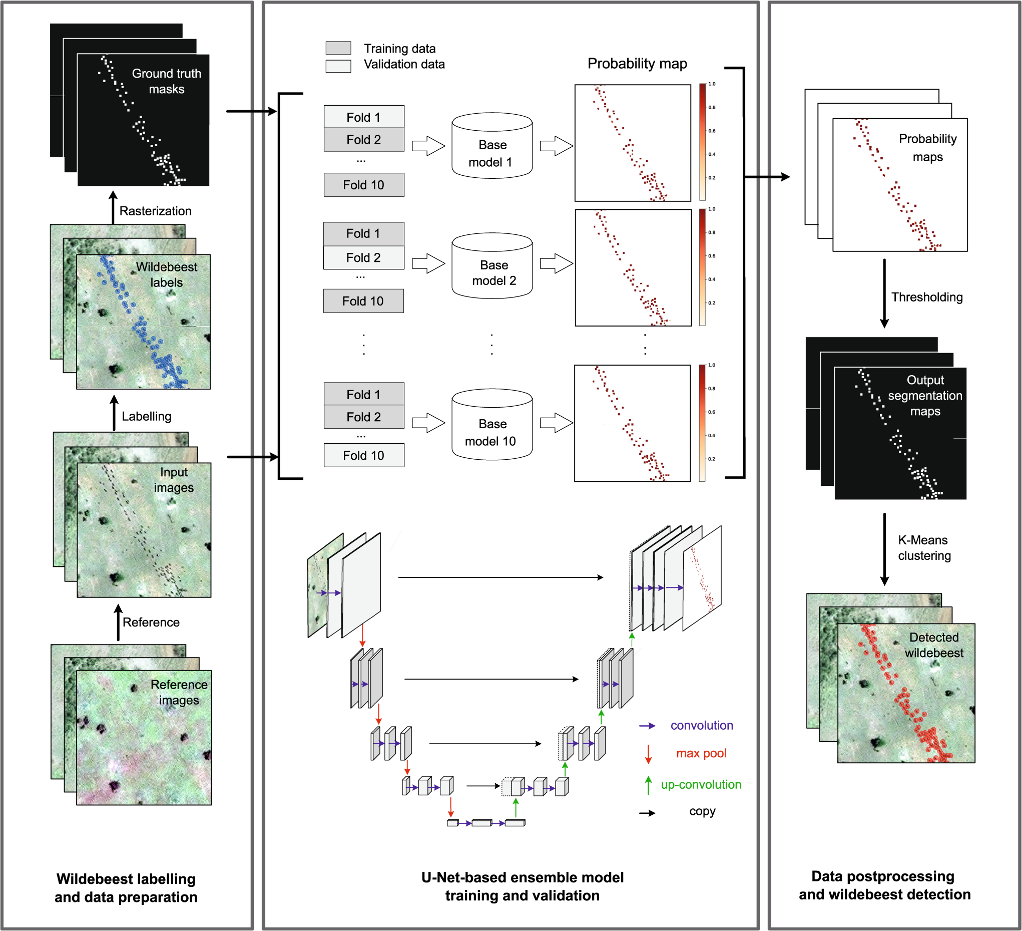
Deep learning enables satellite-based monitoring of large populations of terrestrial mammals across heterogeneous landscape
Nature Communications - This study presents a deep learning pipeline to automatically locate and count large herds of migratory ungulates (wildebeest and zebra) in the Serengeti-Mara ecosystem...
 Nature
5 November 2023 9:04pm
I'm registered with the TWS2023 app, so feel free to nudge me there as well