GIS, or Geographic Information Systems, play a crucial role in nature conservation. Every day, mapping and spatial analysis are aiding conservation decisions, protected areas designation, habitat management on reserves and monitoring of wildlife populations, to name but a few examples. Want to learn more about how remote sensing is used in conservation? Check out the first two episodes of this season of Tech Tutors, where our Tutors answer the questions How do I use open source remote sensing data to monitor fishing? and How do I access and visualise open source remote sensing data in Google Earth Engine?
You can also check out our Virtual Meetup Archive for a range of panels that overlap with Remote Sensing & GIS topics.

- @CynthiaGw
- | Her/she
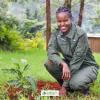
Hi, Cynthia Gichimu here. I'm a conservationist, and a champion for youths. I believe in environmental sustainability for posterity. I volunteer as a Project Officer with the Friends of Kinangop Plateau, a community-based local action group committed to biodiversity conservation.
- 1 Resources
- 2 Discussions
- 6 Groups

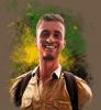
Ramiro is an ecologist whose research interests are in the fields of applied animal ecology and conservation biology. He addresses critical research questions by integrating a combination of field data collection, GIS, remote sensing, and advanced modelling techniques.
- 0 Resources
- 0 Discussions
- 7 Groups

- @Gopal_Khanal
- | He/him
I am a conservation biologist working for wildlife conservation in Nepal. My current research focuses on understanding how species respond to novel anthropogenic threats in space and time using technology like camera traps and GPS collars.
- 0 Resources
- 0 Discussions
- 3 Groups

- @kara_birk
- | She/Her
Advancing the international partner engagement work of ABALOBI, a tech platform aimed at integrating small-scale fishers into information and resource networks.
- 0 Resources
- 0 Discussions
- 8 Groups

- @Robincrocs
- | He/Him//El//Ele
Wildlife biologist, works with Caimans and Crocodiles
- 0 Resources
- 0 Discussions
- 14 Groups

Remote Sensing Surveyor with interest in GIS, data science and bioacoustics.
- 0 Resources
- 0 Discussions
- 3 Groups

International Union for the Conservation of Nature (IUCN)
Key Biodiversity Areas Programme Officer, IUCN


- 0 Resources
- 89 Discussions
- 8 Groups

- @kadambarid
- | she, her, hers
Dr. Kadambari Devarajan is an engineer-turned-ecologist working on biodiversity monitoring. (Website - http://kadambarid.in/)
- 0 Resources
- 0 Discussions
- 14 Groups
- @a.zubiria
- | she/her
- 0 Resources
- 0 Discussions
- 11 Groups
- 0 Resources
- 0 Discussions
- 8 Groups
- @SteveT
- | He/Him
Ex-acedemia, now in the ‘wild’ (corporate slave), part time field biologist.
- 0 Resources
- 0 Discussions
- 1 Groups
I studied sustainability and worked in the international dev sector, I have tech skills in UX, data-analytics and graph modelling, can prototype web services and want to help in nature conservation.


- 0 Resources
- 17 Discussions
- 4 Groups
Careers

This role will be employed under Osa Conservation's Movement Ecology Program. Broadly, the project aims to develop and use novel animal tracking technology to increase our understanding of the movement ecology of...
22 September 2022
Article
Collecting Critically Endangered Plants on Cliffs using a Drone

Guillaume Charron
This technology was recently tested in Kauai, Hawaii, with the National Tropical Botanical Garden and has successfully collected from 5 critically endangered species that were otherwise inaccessible.
16 September 2022
Careers

At the Inria Sophia Antipolis - Méditerranée center. The project will pursue two different methodological goals: (1) explore the use of natural language bottlenecks describing visible traits or other visual...
1 September 2022
Careers

Seeking interested individuals with qualifications and educational background and experience in marine species biology/ecology (marine mammals, sea turtles, fish, seabirds, etc.); with skills in applied scientific study...
31 August 2022
Careers

Hey space & nature conservation enthusiasts! For an innovation project about forest impact monitoring, I am looking for a student assistant with the option to write a Master thesis.
29 August 2022
Careers
Conservation Technology Research Internship
Meredith Palmer
Boost cons tech capacity at an international NGO! Fauna & Flora International is offering a paid three-month internship to consolidate and share best practices for the application of emerging hardware and software...
26 August 2022
Careers
The incumbent will conduct research to advance the integration of wildlife tracking & space-based remote sensing, serve as a member of the multi-agency Internet of Animals project & participate as an inter-...
25 August 2022
Funding
RCMRD Map Competition 2022
Netty Cheruto
Through this Competition, RCMRD aims to enhance the role of Geo-conservation in Protected Areas Management and Environmental Conservation. With a Total Prize Tag of 10,000 Euros, participants will be required to use...
19 August 2022
Careers

The Marine Robotics and Remote Sensing (MaRRS) Lab at Duke University seeks a highly motivated UAS pilot and geospatial analyst to support the ongoing development of new and existing research and conservation programs,...
10 August 2022
Careers
The Marine Robotics and Remote Sensing (MaRRS) Lab at Duke University seeks a highly motivated postdoctoral researcher to support the ongoing development of new and existing research and conservation programs, both...
10 August 2022
Careers
Smithsonian Conservation Biology Institute (SCBI) & International Fund for Houbara Conservation (IFHC)
22 July 2022
Article
CERES TAG

Kim Lane
Ceres Tag sends just in time alerts and GPS location to have the power to track and trace.
22 July 2022
June 2024
event

Cassie Anderson
July 2024

September 2024

September 2023
event
Cassie Anderson
August 2023
event

Li Ling Choo
July 2023

112 Products
Recently updated products
| Description | Activity | Replies | Groups | Updated |
|---|---|---|---|---|
| Hi Cathy, please check out what Alex sent and DM me if you're still interested in co-leading the group. Thanks.Vance |
|
Remote Sensing & GIS | 3 hours 9 minutes ago | |
| Depending what you want to do, there are free services to annotate values for each point, interpolating between available time-location records in the RS data.The EnvDATA Track... |
|
Remote Sensing & GIS | 1 week 4 days ago | |
| Hi folks!@Chelsea_Smith from Fauna & Flora joined last month's variety hour to share more about Fauna & Flora's work with... |
|
Remote Sensing & GIS, Data management and processing tools, Protected Area Management Tools | 1 month 1 week ago | |
| Calling practitioners working in connectivity... we're doing some thinking around modelling functional connectivity, and the data that... |
|
Remote Sensing & GIS | 1 month 2 weeks ago | |
| Thank you Carly, I will definitely take a look. |
|
Acoustics, Biologging, Climate Change, Conservation Tech Training and Education, Data management and processing tools, Remote Sensing & GIS, Software and Mobile Apps | 2 months 1 week ago | |
| We will be conducting in-person demos of our cutting-edge drone technology in the US this year! 🇺🇸 If you're interested in experiencing... |
|
Biologging, Drones, Remote Sensing & GIS, Software and Mobile Apps | 3 months 2 weeks ago | |
| Am working on similar AI challenge at the moment. Hoping to translate my workflow to wolves in future if needed. We all are little overstretched but it there is no pressing... |
|
Camera Traps, AI for Conservation, Build Your Own Data Logger Community, Data management and processing tools, Marine Conservation, Protected Area Management Tools, Remote Sensing & GIS | 4 months ago | |
| Real nice video. I'll have another look in the weekend in detail. |
+10
|
Acoustics, Community Base, Protected Area Management Tools, Remote Sensing & GIS, Sensors | 4 months ago | |
| Hi!I would take a look at Although developed for camera trap imagery, it is by no means restricted to such.Cheers,Lars |
|
Camera Traps, Community Base, Data management and processing tools, Drones, Emerging Tech, Remote Sensing & GIS, Software and Mobile Apps | 4 months ago | |
| Thank you for the links. As a trainer in GIS I have gone through them and they are very helpful for a beginner in QGIS. |
|
Remote Sensing & GIS | 4 months 1 week ago | |
| Thank you for this! Will take a look. |
|
Climate Change, Conservation Tech Training and Education, East Africa Community, Remote Sensing & GIS | 4 months 2 weeks ago | |
| Appreciate that Lars! |
+20
|
Biologging, Remote Sensing & GIS | 4 months 4 weeks ago |